

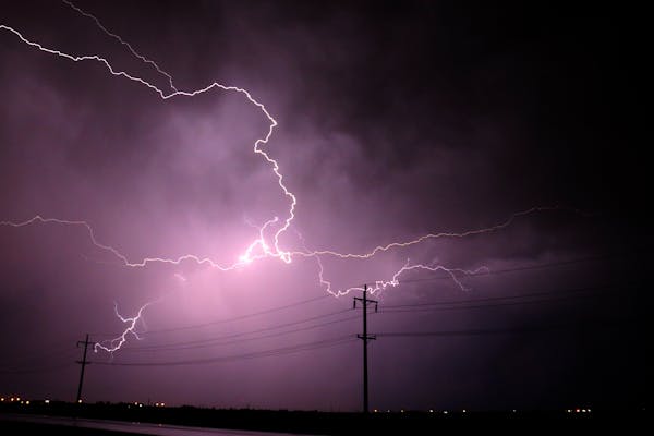
Met Éireann has updated it’s nationwide thunderstorm alert to Status Orange, with a warning for “flooding where heavy downpours occur”.
The alert comes into effect from 3pm today until 9am tomorrow morning.
"Thunderstorm activity expected. Due to the sporadic nature of development, not all areas will be affected. Heavy downpours of rain and hail will occur in places. Flooding where heavy downpours occur,” Met Éireann said.
The UK’s Met Office has also issued a status yellow warning for counties Antrim, Armagh, Down, Fermanagh, Tyrone, Derry from 9am today until midnight tonight.
A separate status orange thunderstorm warning has been issued for counties Carlow, Kilkenny, Wexford, Wicklow and all six counties in Munster from 9am tomorrow morning until 4 o’clock in the afternoon.
Meanwhile, a yellow high temperature warning is in place for counties Leinster, Munster, Cavan, Monaghan, Galway and Roscommon until 6am tomorrow.
Yesterday saw scorching heat across the country, with Oak Park in Co Carlow once again recording a high of 30.7C.
Here are today's highest air temperatures from across the Met Éireann network. With the widespread sunny & hot weather, some stations climbed above 30°C once more 🥵☀️
— Met Éireann (@MetEireann) August 13, 2022
Similar temperatures expected tomorrow, but thunderstorms too! ☀️⛈️
More here 👇https://t.co/9gKN6SVok4 pic.twitter.com/LySrJmKOlE
Pressure on water schemes statewide has increased due to the recent high temperatures and lack of rain. Irish Water has issued a warning, noting that actions had been made at 37 of its 750 water sources nationwide "to ensure taps stay running" in the face of increased demand.
Customers are still not affected in the majority of cases, although there are a few places where overnight limitations are in force.
These comprise a portion of Kerry, West Cork, and Galway. Several townlands in Co. Donegal have been affected by nighttime restrictions that are also in effect at the Carrigart and Lough Mourne water schemes.
Irish Water is closely monitoring over 60 supplies around the nation in addition to the areas where active interventions are taking place to make sure that the usual supply is maintained throughout the remainder of the summer and into the fall.
"We would like to thank the public for their help in conserving water to date and advise everyone to continue taking some easy actions to reduce their usage," said Tom Cuddy, Head of Asset Operations at Irish Water. We can all help to prevent further restrictions and ensure there is enough water for homes and businesses, agriculture, fisheries, and essential amenities as we proceed through the remainder of the Summer and into Autumn by reducing our water use, such as turning off the hose and avoiding power washing.
The Orange Forest Fire Warning from the Department of Agriculture is still in force until Tuesday at noon due to "weather patterns and projected level of risk."
We have an Orange Fire Warning in place for another few days.
— Charlie McConalogue (@McConalogue) August 13, 2022
The video below is terrifying. Well done to all involved for their quick thinking to minimise damage.
With fields a hive of activity, please keep an eye out for your neighbours. Early intervention is crucial. https://t.co/b9Ix0Qzgp6
According to Met Éireann, today will be another hot day, with temperatures typically ranging from 24 to 30 degrees Celsius, especially in Munster and south Leinster.
Northwest regions and other coastal regions where coastal fog may linger and sea breezes may develop may have colder temperatures.
Throughout the day, a few isolated heavy showers or thunderstorms may form, and in the late afternoon and evening, they will gradually intensify and become more widespread.
The "most powerful slow-moving deluges," according to the forecaster, will produce intense lightning, some spot flooding, and a small probability of hail.
Overnight, sporadic heavy showers and thunderstorms will persist and occasionally combine to form prolonged periods of rain, with the possibility of localised downpours and spot flooding. Temperatures will drop to between 11 and 13 degrees Celsius in Ulster and north Connacht while remaining above 14 to 17 degrees Celsius elsewhere. It will continue to be warm and humid.
Tomorrow, the southern half of the country will continue to have sporadic showers and thunderstorms, according to Met Éireann. Through the afternoon, there will be heavier rain and a greater chance of flooding.
Further north, it will be fresher but drier, with just sporadic showers and brief sunny periods. The highest temperatures will once again be more typical, averaging between 17 and 23 degrees Celsius elsewhere and 14 to 16 degrees Celsius in the north and northwest.
A generally dry night with clear periods and lows of 10 to 15 degrees Celsius will prevail on Monday night as rains in the south gradually fade away. The east coast will continue to be the warmest place.
Tuesday will be cooler and cloudier than Monday, with sporadic light showers and highs of 15 to 19 degrees Celsius, with the south experiencing the mildest conditions.
Tuesday night will be dry with a mix of clouds, clear periods, and lows of 8 to 13 degrees Celsius. The showers will end early.
On Wednesday, there will be no rain. The morning will have some cloud cover and bright intervals, with a large area of hazy sunshine forming in the afternoon. Highest temperatures of 15 to 20 C are anticipated, according to Met Éireann, with the south coast seeing the warmest conditions.
There will be clear periods early on Wednesday night, but clouds will gather from the west and rain will move inland near daybreak. The west will experience the mildest lows, between 8 to 14 degrees Celsius.
On Thursday, a band of rain that could occasionally become heavy will traverse the nation in the morning, followed by sporadic showers in the afternoon. Through the evening, the rain will stop and be replaced by more frequent sunshine periods in the west. Warmest in Munster, highest temperatures of 16 to 22 C are anticipated.
Despite the fact that confidence is still quite low for the weekend after next, Met Éireann predicted that conditions would eventually become milder and more stable.

.png)
The opinions posted here do not belong to 🔰www.indiansdaily.com. The author is solely responsible for the opinions.
As per the IT policy of the Central Government, insults against an individual, community, religion or country, defamatory and inflammatory remarks, obscene and vulgar language are punishable offenses. Legal action will be taken for such expressions of opinion.